| ЭЛЕКТРОННАЯ
БИБЛИОТЕКА КРЫМСКОГО ФИЛИАЛА ИНСТИТУТА АРХЕОЛОГИИ НАН УКРАИНЫ
ВСЕ ПРАВА ЗАЩИЩЕНЫ
Chabai
Viktor P. Kabazi II: Stratigraphy and Archeological Sequence
//
Kabazi II: Last Interglacial occupation, environment and subsistence
/ V. Chabai, J. Richter, and Th. Uthmeier, eds. – Simferopol, Cologne:
Shlyakh, 2005. – P. 1-21: il.
Kabazi
II, which is one of four Middle Palaeolithic open-air sites
located in the Crimea, is of particular importance as it
is home to the longest stratigraphical sequence of Upper
Pleistocene sediments thus far discovered at any Crimean
or Eastern European site.
SETTING
Kabazi II is situated on the
right bank of the Alma River, on the southern slope of the
Kabazi Mountain, a cuesta belonging to the second (internal)
ridge of the Crimean Mountains. The site lies on the upper
part of the slope, 90 m above the Alma River channel, and
70 m from a limestone cliff which towers 33 m over the site.
(Fig. 1-1, 1, 2). The elevation of Kabazi II is 302.14 m
above sea level. In two parts of the site the remnants of
a third river terrace were uncovered. Whilst these are situated
at an elevation of between 280 m and 270 m above sea level,
the lowermost in situ occupation of Kabazi II was discovered
at an elevation of 290.9 m above sea level. Naturally, this
topographical situation has contributed greatly to the geological
history of the site which has witnessed a series of rock-falls,
as well as colluvial, alluvial and pedogenetic processes.
Five further Middle Palaeolithic sites (Fig. 1-1, 1) were
investigated on the slopes of the Kabazi cuesta. These comprise
two collapsed rock-shelters (Kabazi I and Kabazi V) and
three locations with surface scatters (Kabazi III, Kabazi
IV and Kabazi VI).
EXCAVATION
STRATEGY
The
excavation of the site began with a sondage on squares 10ИК?
and 11ИК?, whereby the one square metre grid was adopted.
During the second field season (1987), and parallel to the
sondage excavation, the bigger area on square lines 4, 5,
6, 7 and 8 was opened (Fig. 1-2, 1). A sondage which was
undertaken in the same field season exposed more than 10
m of sediments. After 1987, the sondage was refilled with
back dirt. In the following seasons, two areas were excavated:
first, on the square lines 4, 5,
P.1
|
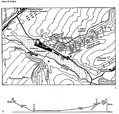 Fig.
1-1 Kabazi II, topography: 1 - map of the Alma River Valley
near the Kabazi group of sites, Roman numerals indicating
the archaeological sites, a - a1 location of topographic
cross-section across Alma River Valley; 2 - topographic
cross-section across Alma River Valley and through Kabazi
II site. Fig.
1-1 Kabazi II, topography: 1 - map of the Alma River Valley
near the Kabazi group of sites, Roman numerals indicating
the archaeological sites, a - a1 location of topographic
cross-section across Alma River Valley; 2 - topographic
cross-section across Alma River Valley and through Kabazi
II site.
6,
7 and 8; and second, on square lines 10 and 11. The first
area measures roughly 60 m2 on the surface and 20 m2 at
its base (-11,5 m elevation on Fig. 1-2, 2). The lowest
point of the first area is 14,10 m on the squares 4H,
4O and 4П. The second excavation area consists of 12 m2
both on the surface and at the base of the pit.
All archaeological levels
were excavated following the angle of inclination of the
exposed sediments.
The
most common type of occupation to be observed in Kabazi
II is the co-called "carpet floor" or "carpet
level" which is characterised by a thin level of
archaeological material (usually with the thickness of
a single bone or artefact). The "carpet levels"
are subdivided by sterile sediments of varying thickness.
The excavation of "carpet" levels in lithologically
monotonous sediments requires an exact documentation of
elevation. No less than 10
P.2
|
| 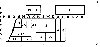
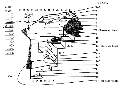
Fig.
1-2 Kabazi II, excavated area: 1 - plan of excavated area;
2 - layout of excavated area, square lines 4, 5, 6, 7 and
8.
elevations
were taken in each square metre excavated. All finds,
including the limestone blocks, were mapped at a scale
10:1. The faunal remains and the limestone blocks were
plotted in the same scale and actual shape. Artefacts
were mapped in conventional signs according to class or
tool type. The sediments surrounding fauna or artefact
clusters were sieved using a 1,5 mm screen. Additionally,
water screening was employed for selected squares to recover
snails and the rests of rodents.
P.3
|
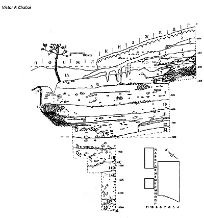
Fig.
1-3 Kabazi II, section along the line of squares 8/9: Arabic
numerals indicate strata, combined Roman and Arabic numerals
indicate archaeological levels.
STRATIGRAPHICAL
SEQUENCE
The
stratigraphical sequence of Kabazi II is contained in about
14 m of sediments comprising 26 lithopedological Strata
(Fig. 1-3 and 1-4). There follows a general description
of the lithopedological events observed at Kabazi II based
on the studies conducted by R. Ferring which focused on
the upper part of the sequence, and the descriptions provided
by N. Gerasimenko for the lower part of the profiles (Ferring
1998a, 1998b, Gerasimenko, Chapter 2, this volume).
Stratigraphy
Stratum
1A - modern and Pleistocene sediments re- deposited by present
day human activity.
Strata
1 and 2 - modern soil formed in colluvial sediments and
represented by granular silt with angular to sub-angular
limestone debris. The lower boundary is clear (Fig. 1-3,
1-4 and 1-5).
P.4
|
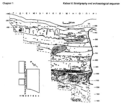 Fig.
1-4 Kabazi II, section along the line of squares 3/4: Arabic
numerals indicate strata, combined Roman and Arabic numerals
indicate archaeological levels. Fig.
1-4 Kabazi II, section along the line of squares 3/4: Arabic
numerals indicate strata, combined Roman and Arabic numerals
indicate archaeological levels.
Stratum
3 - a yellowish granular loam fill with angular and sub-angular
limestone cobbles with carbonate coasts and soft carbonated
masses, penetrated by root channels reaching down into
the lower strata. The gradient of this stratum corresponds
to that of the modern slope surface. Stratum 3 is clearly
distinguishable and - on square lines 11 through to 6
- is separated from Stratum 4 by a clear boundary (Fig.
1-3 and 1-5). Such a boundary was, however, not observed
on square lines 5 and 4 (Fig. 1-4).
Stratum
4 - loose light grey loam filled with weathered limestone
debris. Stratum 4 is truncated by colluvium from Stratum
3 on the squares 7E, 8E and 9E (Fig. 1-3). The gradient
of Stratum 4 closely resembles that of both Stratum 3 and
the modern slope. Its lower boundary is clearly visible.
Stratum
5 - grey-brown, compacted silty loam with granular structure
and fine debris. The upper boundary is truncated by the
colluvuim of Stratum 4Fig. 1-3). On the squares 10-11B,
10-11Г and 10-11Д the deposits of Stratum 5 are disturbed
by erosion (Fig. 1-5). The lower boundary is clear and roughly
horizontal. The undisturbed deposits of Stratum 5 were found
on the squares 10-llЯ, 10-11A, 8Г, 8Д, and partially on
square lines 7Г and 7Д.. The gradient of the undisturbed
deposits of Stratum 5 is more or less horizontal.
Stratum
6 - light-brown, silty loam, compacted with a large amount
of angular and sub-angular limestone eboulis which is concentrated
on square lines Г, Д and E (Fig. 1-3 and 1-5). The gradient
of Stratum 6 is circa 7° from north to south. Both upper
and lower boundaries show evidence of erosional disturbance.
Stratum 6 was found on square lines 11 to 7, and to a certain
extent on square line 6.
Stratum
7 - light-grey loam compacted with large angular limestone
cobles and sub-rounded eboulis
P.5
|
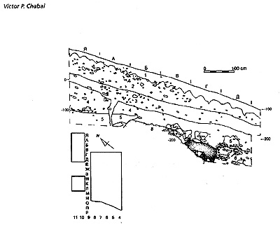 Fig.
1-5 Kabazi II, section along the line of squares 9 /10:
Arabic numerals indicate strata. Fig.
1-5 Kabazi II, section along the line of squares 9 /10:
Arabic numerals indicate strata.
lenses.
The limestone debris is concentrated on square lines Г,
Д, E and Ж (Fig. 1-3). On square lines Д, E and Ж the
sediments of this stratum are disturbed by animal tunnels
(Fig. 1-3 and 1-4). The gradient of Stratum 7 is 5-6°
from north to south. The upper boundary of Stratum 7 was
truncated by latter erosion. Whilst the lower boundary
of Stratum 7 is clear and runs horizontally on square
lines 8, 7, and for part of square line 6 (Fig. 1-3),
it exhibits the pronounced traces of earlier erosion on
square lines 4, 5, and - to a certain degree - also on
square line 6 (Fig. 1-4). Stratum 7 covers the entire
excavation.
Stratum
8 comprises the limestone block which was found on squares
11Б, 10Б,11B, 10B, 11Г, 10Г", 8Г", 7Г, 6Г, 5Г,
4Г, 7Д, 6Д,5Д, 7E and 6E (Fig. 1-2,1-4 and 1-5). Taking
into account the unexcavated line of squares 9, the total
area covered by the limestone block is about 20 m2. The
surface of this block is heavily weathered and dissolute.
This block was the source of angular and sub-angular limestone
cobbles and eboulis found in Strata 6 and 7 on square
lines Г, Д, E and Ж. The visible lower boundary of this
block corresponds to the boundary between Strata 8 and
9 (Fig. 1-4).
P.6
|
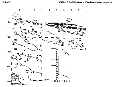 Fig.
1-6 Kabazi II, section along the line of squares И / K:
Arabic numerals indicate strata. Fig.
1-6 Kabazi II, section along the line of squares И / K:
Arabic numerals indicate strata.
Stratum
11 (upper) - a dark-grey-brown silty loam with limestone
debris and limestone angular boulders near the limestone
barrier - Stratum 17 (Fig. 1-4). The gradient of Stratum
11 (upper) is about 5-6, 5° from north to south. The lower
boundary is horizontal and clearly visible on square lines
4 and 5 (Fig. 1-4). On square lines 8, 7 and 6 the lower
boundary is, however, not pronounced (Fig. 1-3).
Stratum
11 (lower) - a light grey-brown loose loam filled with
fine limestone debris and angular limestone boulders which
are mainly concentrated on square lines П, O, H, M, ?
and K located near the limestone barrier - Stratum 17
(Fig. 1-3 and 1-4). The gradient of Stratum 11 (lower)
is circa 5-6,5° from north to south. The lower boundary
of Stratum 11 (lower) is gradual.
Stratum 12 - this stratum
comprises the limestone block found on the squares 8E,
8Ж and 8З. The surface of this block is angular and shows
no traces of weathering. The visible lower part of this
block probably corresponds to the boundary between Strata
11 lower and 13 (Fig. 1-3).
Stratum
13 - a light grey-brown loose loam with fine limestone
debris, a small clay component and carbonate filaments.
Stratum 13 is not so densely filled with limestone debris
as Stratum 11 (lower), but shows evidence of carbonate
filaments. These were the reasons for the subdivision
of Stratum 13 and 11 (for more detailed discussion: Gerasimenko,
this volume). Stratum 13 covers the entire excavation.
The gradient of Stratum 13 is about 6,5° from north to
south. The lower boundary of Stratum 13 which is to be
observed on square lines 4, 5 and partially on square
line 6, is gradual and contains sand and clay lenses of
the underlying Stratum 13A (Fig. 1-4). The lower boundary
of Stratum 13 on square lines 7, and to a certain extent
on square lines 8 and 6, is wavy (Fig. 1-6).
Stratum
13A - this stratum is represented by alternations of horizontal
thin coarse sand lenses and thin lenses of brown clay
of clear alluvium genesis. Stratum 13A is found in the
lowest southern part of the excavated area on square lines
4, 5 and partially on square line 6 (Fig. 1-4 and 1-6).
P.7 |
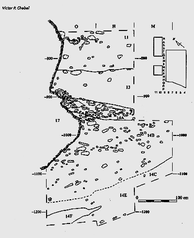 Fig.
1-7 Kabazi II, section along the line of squ
ares
6/7: Arabic numerals indicate strata, combined Roman and
Arabic numerals indicate archaeological levels. Fig.
1-7 Kabazi II, section along the line of squ
ares
6/7: Arabic numerals indicate strata, combined Roman and
Arabic numerals indicate archaeological levels.
Stratum
14A - a dark-grey compacted loam with a granular structure
containing large and small pieces of angular limestone
gravel concentrated mainly near the limestone barrier
- Stratum 17. Stratum 14A was found on square lines
4, 5, and partially on 6, 7, and 8 (Fig. 1-4 and 1-6).
The upper part of Stratum
14A on square lines 4, 5 and to a certain extent on
square line 6, was truncated by alluvium from Stratum
13A. On the squares 6M, 6H, 6O, 7M, and partially on
7K and 7?, Stratum 14A underlies Stratum
13 (Fig. 1-7). On the mentioned squares the boundary
between Strata 13 and 14A is clear. The boundary between
Strata 14A and 14B is also evident (Fig. 1-4, 1-6 and
1-7). The gradient of Stratum 14A is roughly 8-10° from
north to south.
Stratum
14B - a light-grey compacted loam with a granular structure
and filled with different size
P.8
|
pieсes
of angular limestone gravel in its upper part, and with
rare sub-rounded and rounded limestone debris in its lower
part (Fig. 1-3, 1-4, 1-6 and 1-7). Furthermore, the gravel
from the lower parts of Stratum 14B lies at different gradients.
The gradient of the over-lying gravels is circa 11° from
north to south. On the other hand, the gradient of the lower-lying
debris in the same direction is about 35° (Fig. 1-4 and
1-7). However, the boundary between the lower and upper
parts of Stratum 14B is not only evident in the varying
gradients and density of limestone debris, but also in their
relationship to the base of limestone barrier - Stratum
17 (Fig. 1-4 and 1-7). The lower boundary of Stratum 14B
on square lines K, ?, M, and partially H, is wavy, on the
square lines П, O and partially H is not distinguishable
(Fig. 1-3, 1-4, 1-6 and 1-7).
Strata
14C, 14D,
14E, 14F, 15, 16 - these strata are represented by whitish
(14C), greyish (14D), greyish-green (14E), green (14F),
yellow (15) and white (16) clayey and sandy loams with rounded
limestone gravel. Some of these strata even cover the entire
excavation: strata 14E and probably 15 and 16. Others were
observed clustered on particular squares: strata 14C, 14D
and 14F. All of them have gradients ranging from 25° to
45° depending on their position within the excavated area.
The boundaries between these strata are of irregular character
(Fig. 1-3, 1-4, 1-6 and 1-7).
Stratum
17 - this stratum comprises a limestone
block (Fig. 1-3 and 1-4), the visible parameters of which
are: height - about 8 m, length - at least 12 m, thickness
- no less than 10 m. The block was found on square lines
O, П, P. The visible part of its base lie in Stratum 14B
(Fig. 1-4 and 1-7). The elevation of the barrier base is
about 290 m above sea level. It should be borne in mind
that the elevation of the present day surface of the 3rd
Alma River terrace is 268 m above sea level.
Stratum
17A - the dissolute part of the limestone block - Stratum
17 (Fig. 1-3 and 1-4).
Formation
processes
At
least 4 natural processes were responsible for the deposition
of the stratigraphical sequence of Kabazi II:
-
Colluvial processes are apparent in each of the strata,
this is evidenced by the varying size of sub-rounded
and rounded limestone debris, sandy, silty and clayish
sediments, as well as larger limestone blocks as characterised
by Strata 8,12 and 17.
-
Pedogenetic processes which are the most pronounced
in the formation of Strata 14A, 14B, 11 upper, 7, 5,
and certainly in the modern soil of Strata 1 and 2.
-
Alluvial processes produced the alternated sandy and
clayish lenses of Stratum 13A.
-
Exfoliation of the limestone blocks from Strata 17 and
8 which produced a large amount of angular and sub-angular
gravel in Strata 6 to 14B.
The
geological history of Kabazi II might be described in the
following terms. The huge limestone block (Stratum 17),
which obviously originates from the cliff of the cuesta,
fell onto the relatively eroded slope bench which more or
less corresponds to the river terrace, it being about 20
m above the surface of the present day remnants of the 3rd
terrace of the Alma River (Fig. 1-1, 2). This block which
creates a barrier that trapped colluvium behind it, led
to the series of lithopedological events. The beginning
of the stratigraphical trap at Kabazi II starts with the
deposition of soil, colluvium and limestone debris from
barrier exfoliation - Strata 14 upper and 14A (Fig. 1-3,1-4
and 1-7). By the deposition of Stratum 14B, the relatively
horizontal surface had formed behind the limestone barrier.
The accumulation of Stratum 14A was interrupted and partly
eroded by alluvium from Stratum 13A (Fig. 1-4 and 1-6).
This alluvium is also seen during the beginning of formation
of Stratum 13. The alluvial deposits of Stratum 13A might
be the result of seasonal flooding. The absence of large
pebbles in Stratum 13A suggests a low-energy mode of alluvium.
At the same time, alluvium made the platform behind the
barrier more horizontal. The gradients of the strata before
and after alluvium differ in about two times. The combination
of colluvial sediments and barrier exfoliation are responsible
for deposition of Stratum 13 and lower part of Stratum 11
(Fig. 1-3 and 1-4). While, in the upper part of Stratum
11 this combination was added by soil formation process.
During Stratum 13 accumulation one more big limestone slab
(Stratum 12) fell on the site area (Fig. 1-3). Colluvial
sediments and limestone gravel from barrier exfoliation
are responsible for Strata 10 and 9 accumulations. At the
end of Stratum 9 deposition, the soil formation process
becoming more pronounced and one more limestone slab (Stratum
8) fell on the site area (Fig. 1-2, 2). At the same time,
the end of Stratum 9
P.9
|
accumulation
was characterised by the surface erosion (Fig. 1-4). The
formation of Stratum 7 was cased by the number of agents:
the colluvial from up-slope area, the soil formation process
and the exfoliation of limestone blocks (Strata 17 and
8). During Stratum 7 formation these limestone blocks
(each about 1 m high and more than 10 m long) create the
horizontal platform between them, which might be the most
comfortable place on the slope of cuesta at that time.
However, the stratigraphical trap was filled to capacity
by sediments. The accumulation of the next Strata 6 and
5 was opened to the slope erosion. These Strata were found
in a more or less preserved condition behind and near
the limestone block (Stratum 8), which was the last Pleistocene
sediments trap in Kabazi II geological history (Fig. 1-3
and 1-5). The Strata 4 and 3 are represented by the transported
from up-slope Pleistocene deposits, while Strata 2 and
1 is the result of modern soil formation process (Fig.
1-3, 1- 4 and 1-5).
ARCHAEOLOGICAL SEQUENCE AND OCCUPATION CHARACTERISTICS
However,
there was also a fifth process responsible for the formation
of the Kabazi II stratigraphical sequence - human activity.
The sediments of Kabazi II contain the remains of 55 in
situ human occupations and 21 further levels comprising
re-deposited and transported artefacts (Table 1-1). The
archaeological material was found in all strata, except
in Strata 14C, 14E, 15 and 16. The in situ occupations
are represented by 20 archaeological levels with Western
Crimean Mousterian (WCM) industry and 35 archaeological
levels with Crimean Micoquian. The archaeological levels
constitute 8 Units. Unit I includes four archaeological
levels: from I/1 to 1/3. Unit A is represented by 8 archaeological
levels: from A to A4. Unit II comprises 14 archaeological
levels: from II/1A to II/8C. Unit IIA includes 8 occupations:
from IIA/1 to IIA/4B. Unit III is represented by 15 archaeological
levels: from III/1A to III/8E. Unit IV is subdivided into
5 levels: from VI/1 to IV/5. Unit V consists of 7 archaeological
levels: from V/l to V/6. Unit VI is represented by 15
levels: from VI/1 to VI/17.
There follows a brief description of the previously published
archaeological sequence from Units I, A, II, IIA and III
(Chabai 1998b, 1998c, 1998d, 1999a), and a detailed analysis
of the occupation as found in the archaeological levels
forming Units IV, V and VI.
The
archaeological sequence of Units I, A, II, IIA and III
Levels
I/I and I/2 comprise re-deposited Middle Palaeolithic
artefacts found at different elevations in sediments of
Stratum 2. No faunal remains were discovered in this stratum.
Level I/2A is represented by a small number of re-deposited
Middle Palaeolithic artefacts originating from the sediments
of Stratum 3. No bones were found here either. Archaeological
material from Level I/3 consists of re-deposited bone
and artefact material from Stratum 4. The artefacts from
levels I/1, I/2, I/2A and I/3 are patinated, and the faunal
material heavily weathered. Some bifacial tools, as well
as blade cores, were found in these levels.
Whilst
bone and artefacts originating from levels A, Al, A2 and
A3 were found in the eroded part of Stratum 5, those areas
of this stratum undisturbed by erosion contained four
in situ occupations in levels A3A, A3B, A3C and A4 (Table
1-1). The thickness of these levels is equal to the thickness
of one artefact or bone, and in between each of these
levels sterile sediments were found. The artefacts from
these levels are not patinated, and, although not excellent,
bone preservation is good. The artefacts from these levels
have been attributed to the WCM industry.
Level II/1A was found in
Stratum 6 (Fig. 1-3; Table 1-1). The thickness of this
level corresponds to the thickness of a single bone or
artefact. The density of artefacts in level II/l A is
112 per m3. The artefacts show signs of a slight patination.
On the whole, bone preservation is good, but some bone
surfaces are weathered.The sterile sediments between levels
II/1A and II/l are about 20 cm thick.
Levels II/l, II/2, II/3,
II/4, II/5, II/6, II/7, II/7AB, II/7C, II/7D, II/7E, II/8,
II/8C were found in deposits belonging to Stratum 7 (Table
1-1). The five upper levels (II/l, II/2, II/3, II/4 and
II/5) are concentrated in the northern part of the excavated
area (Fig. 1-3). They are separated by sterile sediments,
the thickness of which varies from between 10 and 20 cm.
The thickness of each of these levels was determined as
being equivalent of the thickness of one single artefact
or bone. The artefact density in these levels varies from
135 to 150 artefacts per m3. The next six levels (II/6,
II/7, II/7AB, II/7C, II/7D and II/7E) were discovered
in the southern part of the excavated area (Fig. 1-4).
The thickness of the sterile sediments separating them
is in each case roughly 3 cm. The thickness of the individual
levels varies in thickness from that of a single find
to 5 cm. The density of artefacts varies from 80 to 145
artefacts per m3. The main
P.10
|
Strata |
Levels |
Dates,
kyr |
Pollen
zones, # |
Marine
isotopic scale |
|
|
AMS |
U-series |
ESR |
|
|
|
|
|
|
|
|
|
2-3 |
I/1,I/2,I/2A,I/3 |
|
|
|
|
|
4-5 |
A,A1,
A2, A3, |
|
|
|
#XIV,
Bug bg1 |
Stage
2 |
5 |
A3A,
A3B, A3C, A4 |
|
|
|
#XIII,
Vytachiv vt3bDenekamp Interstadial |
|
6 |
II/1A |
|
32,1±6,5 |
30±2,0 |
|
7 |
II/1 |
OxA-4770,
31,55±0,6 |
40,1±5,0 |
|
#XII,
Vytachiv vt2 Humeborg Interstadial |
|
II/2 |
OxA-4771,
35,1±0,85 |
|
|
|
II/3 |
|
|
|
|
II/4 |
OxA-4858,
32,2±0,9 |
|
|
Sterile |
|
II/5 |
OxA-4859,
33,4±1,0 |
|
|
|
II/6 |
|
|
|
|
|
II/7 |
|
46,5±8,0 |
|
#XI,
Vytachiv vt1c Humeborg Interstadial |
|
II/7
AB |
|
|
36±3,0 |
|
|
|
|
38±4,0 |
|
|
II/7
C, II/7 D, II/7 E |
|
|
|
|
|
8 |
II/8 |
|
|
44±5,0 |
#XI,
Vytachiv vt1b2 Hengelo Interstadial |
|
II/8
C |
|
|
|
|
9 |
IIA/1 |
|
|
|
|
|
|
|
|
|
Sterile |
|
IIA/2 |
|
|
|
#IX,
Vytachiv vt1b2-b1 Hosselo Stadial |
|
IIA/2-3 |
|
|
|
|
IIA/3,
IIA/3A, IIA/3B |
|
|
|
#VIII,
Vytachiv vt1b1 Moershoofd Interstadial |
|
10 |
IIA/4 |
|
|
|
|
IIA/4B |
|
|
|
#VII,
Uday ud |
Stage
4 |
11,
upper |
III/1A,
III/1 |
|
|
|
#
VII, Pryluky pl3 |
Stage
4-5 |
|
|
|
Ognon
Interstadial |
transition |
III/2 |
|
54±3,0 |
74-85 |
#VI,Pryluky
pl1b2(pl1b2+3) |
Sub-stage
5a |
Odderade
(Brorup-Odderade) |
Interstadial |
11,
lower |
III/2A |
|
|
|
#V,
Pryluki pl1b2-b1(pl2?) Rederstall
Stadial |
Sub-stage
5b |
III/3 |
|
|
82±10 |
III/4,
III/5, III/6, III/7, III/8 |
|
|
|
III/8A,
III/8B, III/8C, III/8D, III/8E |
|
|
|
#IVC,
IVB-D2, IVA-DI, Pryluky pl1b1Brorup Interstadial |
Sub-stage
5c |
13 |
IV/1,
IV/2, IV/3, IV/4, IV/5 |
|
|
|
13A |
V/1,
V/2, V/2A |
|
|
|
???,
Tyasmin, Herning Stadial |
Sub-stage
5d |
14A |
V/3,
V/4, V/5, V/6 |
|
|
|
#C,
Kaydaky kd3b2+c Eemian (E6b) Interglacial |
14B |
VI/1,
VI/2, VI/3, VI/4, VI/5, VI/6, VI/7, VI/8, VI/9, VI/9A,
VI/10, VI/11-14, VI/15, VI/16, VI/17 |
|
|
|
#III-B4,
III-B3, III-B2, II-B1,A Kaydaky kd3b2+c
Eemian (E6a) Interglacial |
|
|
|
|
|
#A,
Kaydaky kd3b2+b1 Eemian (E6a) Interglacial |
14D |
|
|
|
|
???,
#II, Kaydaky kd3b2-b1 Eemian (E6a) Interglacial |
???
Sub-stage 5d |
14E |
|
|
|
|
???,
#I, Kaydaky kd3b1 Eemian (E5) Interglacial |
???
Sub-stage 5e |
|
Table
1-1 Kabazi II stratigrafical, archaeological, chronological
and environmental data. |
P.11 |
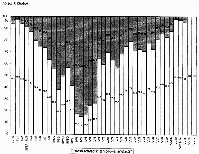 Fig.
1-8 Kabazi II, levels III/1A through VI/17: ratio of "fresh"
and "colluvial" artefacts in each level. Fig.
1-8 Kabazi II, levels III/1A through VI/17: ratio of "fresh"
and "colluvial" artefacts in each level.
concentration
of bones and artefacts from level II/8 was found in the
centre of the excavation area. The thickness of level II/8
varies from the thickness of a single find on its periphery
to 15 cm at the centre of the concentration. The density
of artefacts found in level II/8 is 143,1 per m3. Level
II/8 is separated from level II/7E by 10-15 cm and from
level II/8C by 5 cm of sterile sediment. Level II/8C was
found in the southern part of the excavated area. The thickness
of this level is, once again, comparable with the thickness
of a single bone or artefact. The artefact density for level
II/8C is 43,8 per m3. Very rare patinated artefacts were
found in Unit II assemblages. The preservation of bone surfaces
from Unit II is characterised by some weathering. The artefacts
from Unit II levels belong to the WCM.
Levels IIA/1 and IIA/2 are the lowermost of the WCM sequence.
These were found in the upper
part of Stratum 9 (Table 1-1), in the western / south-western
part of the excavation (Fig. 1-3 and 1-4).
Level IIA/1 is separated from
level II/8C and the underlying level IIA/2 by sterile sediments
measuring 15 cm, the sterile sediments separating Level
IIA/2 from the underlying level IIA/2-3 measure 10 cm. Levels
IIA/1 and IIA/2 vary in thickness from the size of one single
bone or artefact on their periphery, and up to 10 cm in
the central parts of the concentrations. The artefacts are
not patinated, and the bone surfaces are not weathered.
The artefact density for levels IIA/1 and IIA/2 are 40 and
19,3 per m3 accordingly.
The artefacts
and bone remains in levels IIA/2-3, IIA/3, IIA/3A, and IIA/3B
exhibit neither vertical nor horizontal concentrations in
the lower part of Stratum 9 (Table 1-1). The vertical spread
of archaeological material in these levels fluctuates by
about 15 cm in each level. At the same time, the preservation
of artefacts and bones corresponds to the situation in the
uppermost levels of Units II and the upper part of IIA.
The artefact density in these levels is no more than 3-4
per m3. No evidence of artifacts
P.12
|
and
fauna transportation was found. It would appear that the
levels IIA/2-3, IIA/3, IIA/3A, and IIA/3B represent the
extreme periphery of occupational deposits otherwise situated
outside of the excavated area. Some bifacial tools and
bifacial thinning debiting were found in these levels.
It is likely that the artefact assemblages from levels
IIA/2-3, IIA/3, IIA/3A, and IIA/3B belong to the Crimean
Micoquian.
The assemblages of levels
IIA/4 and IIA/4B were discovered in the lower part of
Stratum 10 (Fig. 1-4; Table 1-1). Level IIA/4 is separated
by about 50 cm of sterile sediment from the lowermost
finds of level «IIA/3B. The artefacts from level IIA/4
can be termed as the "living-floor carpet",
which has the thickness of a single bone or artefact.
The artefact density is 27 per m3. The artefacts and faunal
material from level IIA/4B is spread vertically through
the 10 cm thick «sediments of the lowermost part of Stratum
10. The artefact assemblages from both levels are attributed
to the Crimean Micoquian.
The upper part of Stratum
11 comprises the occupational deposits from levels III/1A,
III/1 and III/2 (Fig. 1-3 and 1-4; Table 1-1). Levels
IIA/4B and III/1A are separated by 15-20 cm of sterile
sediment. The thickness of the sterile sediment found
between levels III/1A, III/1 and III/2 varies from 9 to
18 cm. The central parts of these occupations were found
on the excavated area. The thickness of each level varies
from that of a single find up to 15 cm on those squares
where the concentrations of faunal remains were excavated.
The artefact density in these levels is traditionally
low - about 12 per m3. The artefacts from levels II1/1A,
III/1 and III/2 belong to the Crimean Micoquian.
The fauna and artefact assemblages
from levels III/2A, III/3, III/4, III/5, III/6,III/7,
III/8, III/8A, III/8B, III1/8C, II1/8D, and III/8E were
found in the lower part of Stratum 11 (Fig. 1-3; Table
1-1). The levels III/2A and III/3 exhibit two pronounced
clusters of bones and artefacts in the central and southern
parts of the excavated area, and at about the same elevation.
It might well be the case that levels III/2A and III/3
are part of the same occupation. Levels III/2A and III/3
are separated by 20 cm of sterile sediments from the overlying
occupation of level III/2, and by 5 cm of sterile material
from the underlying level III/4. The thicknesses of the
sterile sediments between the levels III/4, III/5, III/6,
III/7, and III/8 varies from 5 cm up to 20 cm. Characteristic
for each of these levels is a thin "carpet"
of bones and artefacts. The individual thickness of such
"carpets" corresponds to the thickness of a
single bone or artefact. The artefact density for levels
III/2A, III/3, III/4, III/5, III/6, III/7, III/8 are between
8 and 27 per m3.
The levels III/8A, III/8B,
III/8C, III/8D, and III/8E did
not show any vertical and / or horizontal concentrations.
These levels were located in the lowermost 35-40 cm of
Stratum 11, lower (Table 1-1). Bones are rare, and those
discovered are heavily weathered. The artefacts are rounded,
naturally damaged and patinated. One of the most peculiar
features of Unit III levels is the increasing number of
"colluvial artefacts" . Such artefacts are represented
by relatively small flakes, chips and even tools with
patinated surfaces, and rounded and naturally damaged
edges. "Colluvial artefacts" are found in all
levels and sterile sediments. In Units A, II, and IIA
"colluvial artefacts" rarely constitute more
than 5% of the assemblages. However, between level III/l
and IV/2 the ratio of "colluvial artefacts"
constantly increases (Fig. 1-8). It is probable that the
origin of the "colluvial artefacts" can be linked
with a further site which was situated above Kabazi
II,
and was washed down during the accumulation of the Kabazi
II sequence. In levels III/8A, III/8B, III/8C, III/8D,
and III/8E the amount of "colluvial artefacts"
varies from 43,3 % to 61,7 %. In fact, the "fresh
artefacts" comprise very limited samples, mainly
of flakes and chips. To some extent, the levels III/8A,
III/8B, III/8C, III/8D, and III/ 8E are analogous to levels
IIA/2-3, IIA/3, IIA/3A, and IIA/3B, but with the much
more pronounced contribution of colluvium.
The
archaeological sequence of Units IV, V and VI
Levels
IV/1, IV/2, IV/3, IV/4 and IV/5 were found in Stratum
13 (Table 1-1). The artefacts in these levels show neither
vertical, nor horizontal concentrations. The "colluvial
artefacts" contribute to between 74 % and 84 % of
the total artefact number (Fig. 1-8). In fact, Stratum
13 was subdivided using "artificial" (10-14
cm) levels, on the basis of which artefacts, pieces of
bone and other samples for environmental studies were
collected. However, no faunal remains, including micro-fauna
and snails, were discovered. The only exception is the
skull of a horse (Equus hydruntinus) and a few tube bones
from level IV/4, squares 4O and 4П. The human role in
the accumulation of this bone assemblage is very problematic.
Thus, the assemblages from levels IV/1, IV/2, IV/3, IV/4
and IV/5 are considered to be represented by transported
colluvium artefacts.
The levels V/l, V/2 and V/2A were
found in the lower part of Stratum 13A and in the upper
part of Stratum 14A (Table 1-1). In fact, these levels
form the upper part of the soil from Stratum 14A which
was disturbed by alluvium from Stratum 13A. Some fauna
and artefacts were recovered, as wel
P.13
|
as
a pronounced component of" colluvial artefacts"
(Fig. 1-8).
The levels V/3, V/4, V/5,
and V/6 were discovered in Stratum 14A (Fig. 1-4; Table
1-1). Each of these levels is represented by a thin "carpet".
The thickness of these "carpets" is - in each
of these levels - equal to the thickness of a single bone
or artefact (Fig. 1-9 and 1-10). The individual "carpets"
are separated from one another by layers of sterile sediments
(Table 1-2). The amount of "colluvial artefacts"
is still very high (Fig. 1-8). The artefact density for
levels V/3, V/4, V/5, and V/6 are among the lowest thus
far recorded for the Crimean Middle Palaeolithic (Table
1-3). The main concentrations of artefacts and bones for
these levels were found on the southern and south-eastern
parts of excavated area.
Table
1-2 Kabazi II, Units V and VI, thickness of sterile
sediments between levels. |
Table
1-3 Kabazi II, Units V and VI, density of artifacts
per m3. |
| Levels |
Sterile,
in cm |
Levels |
Density
of artefacts perm3 |
| V/3-V/4 |
4-7 |
V/3 |
44,74 |
| V/4-V/5 |
3-5 |
V/4 |
26,32 |
| V/5-V/6 |
6-8 |
V/5 |
44,74 |
| V/6-VI/1 |
4-7 |
V/6 |
75,7 |
| VI/l-VI/2 |
5-6 |
VI/1 |
44,74 |
| VI/2-VI/3 |
10-11 |
VI/2 |
40,54 |
| VI/3-VI/4 |
5-7 |
VI/3 |
55,26 |
| VI/4-VI/5 |
4-6 |
VI/4 |
39,39 |
| VI/5-VI/6 |
11-15 |
VI/5 |
29,41 |
| VI/6-VI/7 |
14-16 |
VI/6 |
121,88 |
| VI/7-VI/8 |
8-10 |
VI/7 |
53,13 |
| VI/8-VI/9 |
9-11 |
VI/8 |
83,33 |
| VI/9-VI/9A |
20-25 |
VI/9 |
109,38 |
| VI/9A-VI/10 |
14-17 |
VI/9A |
142,88 |
| VI/10-VI/11-14 |
58-65 |
VI/10 |
68,42 |
| VI/11-14-VI/15 |
15-17 |
VI/11-14 |
124,00 |
| VI/15-VI/16 |
6-7 |
VI/15 |
175,00 |
| VI/16-VI/17 |
20-23 |
VI/16 |
75,00 |
| |
|
VI/17 |
100,00 |
Level
V/3 produces the only fire-place known in Kabazi II (Fig.1-9).
The fire-place was found on the squares 6H=-and 7H. The
shape of the fire-place is ovoid, and its maximum dimensions
are: length - 30 cm, width - 20 cm, thickness - 2,5 cm.
The stratigraphy of the fire-place comprises three horizons:
1 - a dark grey horizon densely packed with ash and small
fragments of burned bones (length - 18 cm, width - 8 cm,
thickness - 0,5 cm); 2 - a grey horizon, not so intensively
filled with ash, burned bones fragments and burned limestone
pieces (length - 30 cm, width - 20 cm, thickness - 1.5
cm); 3 - a yellow-red horizon with burnt sediments (length
- 25 cm, width -16 cm, thickness - 0.5 cm).
In
addition, four ashy clusters were studied in level V/6,
square 4H and 5O (Fig. 1-10). The maximum dimensions
of the ashy cluster from square 4H are: length -
38 cm, width - 20 cm, thickness - 0,5 cm. The dimensions
of ashy clusters from square 5O vary and fall within the
following ranges: length - 15-20 cm, width -10-16 cm,
thickness - 0,5 cm.
Stratum
14B contains the remains of the 15 occupations from Unit
VI (Table 1-1). According to stratigraphical peculiarities
described above, Stratum 14B is subdivided into two parts:
upper and lower. The same is true for the archaeological
levels. The levels VI/1, VI/2, VI/3, VI/4, VI/5, VI/6,
VI/7, VI/8, VI/9, VI/9 A, and VI/10 were found in the
upper part of Stratum 14B (Fig. 1-4). The levels VI/11-14,
VI/15, VI/16, and VI/17 comprise the lower part of Stratum
14B. With the exception of level VI/11-14, each of these
levels is represented by a thin "carpet" of
finds no thicker than a single artefact or bone (Fig.
1-11, 1-12 and 1-13). Level VI/11-14 is represented by
a dense concentration of bones on the square lines O and
П (Fig. 1-14). The thickness of the bone concentration
on square 6O is about 20 cm. At the
P.14
|
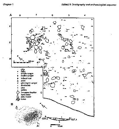 Fig.
1-9 Kabazi II, level V/3: A - site plan; B - detail of site
plan and section of fire-place from squares 6H and 7H, Arabic
numerals indicate horizons: 1 - dark gray horizon, densely
packed by ash and small fragments of burnt bones; 2 - gray
horizon less intensively filled by ash, fragments of burnt
bones and burnt pieces of limestone; 3 - yellow-red horizon
of burnt sediments. Fig.
1-9 Kabazi II, level V/3: A - site plan; B - detail of site
plan and section of fire-place from squares 6H and 7H, Arabic
numerals indicate horizons: 1 - dark gray horizon, densely
packed by ash and small fragments of burnt bones; 2 - gray
horizon less intensively filled by ash, fragments of burnt
bones and burnt pieces of limestone; 3 - yellow-red horizon
of burnt sediments.
the
periphery of occupation (square lines M and H), is equal
to the thickness of a single bone or artefact. Additionally,
there is a pronounced difference in the gradients of the
archaeological levels forming the upper and lower part
of Stratum 14B.
The gradients of levels VIA, VI/2, VI/3, VI/4, VI/5, VI/6,
VI/7, VI/8, VI/9, VI/9A, and VI/10 vary from 8° to 10°
from north to south. On the other hand, the gradients
observed for levels VI/1M4, VI/15, VI/16, and VI/17 increases
to 35° (Fig. 1-4).
The
latter would suggest the trans¬portation of archaeological
material along the slope. However, the amount of "colluvial
artefacts" sharply decreases in the lower part of
Stratum 14B (Fig. 1-8), and the preservation of bone in
the archaeological sequence is much better than in the
upper part of the stratum. Sterile sediments were found
in between all levels of Unit VI (Table 1-2). The most
pronounced sterile sediment is encountered between levels
VI/10 and VI/11-14. In other words, the thickest sterile
layer
P.15
|

Fig.
1-10 Kabazi II, level V/6: site plan.
is
located between the levels of the upper and lower part
of Stratum 14B.
The distribution of archaeological
material in the archaeological levels of Unit VI corresponds
to the area covered by Stratum 14B, which reduces sharply
to¬wards the south. The upper archaeological levels were
found on nearly all squares of the excavated area (Fig.
1-11 and 1-12), although the lowermost are present only
on the most southern squares (Fig. 1-13 and 1-14). The
artefact densities in all levels of Unit VI are low, but
traditional for Kabazi II occupations (Table 1-3).
Therefore, taking into account
the stratigraphi-cal and occupational characteristics
proposed for Units IV, V and VI, it is possible to make
several conclusions:
1. The artefact assemblages from levels IV/1, IV/2, IV/3,
IV/4 and IV/5 are not homogeneous. These assemblages are
the result of the colluvial trans¬port of occupational
deposits which were situ¬ated above Kabazi II.
P.16 |
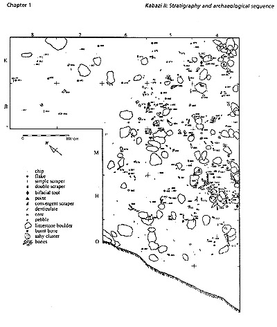
Fig.
1-11 Kabazi II, level VIA: site plan.
2.The
artefacts and faunal assemblages from levels V/l, V/2
and V/2A were found in a secondary context.
These levels were significantly
disturbed by alluvium from Stratum 13A.
3.The artefacts
and faunal assemblages from levels VI/1, VI/2, Vl/3, VI/4,
VI/5, VI/6, VI/7, Vl/8, VI/9, VI/9A, and VI/10 were found
in a primary context.
4.The
artefacts and faunal assemblages from levels VI/11-14, VI/15,
VI/16, and VI/17 were found in a secondary context.
These levels were transported
along the existing slope, although transportation was not
significant, i.e. it did not cause any damage to the surface
of bone or to the edges of artefacts. At the same time,
level VI/11-14 might well be the palimpsest of several occupations
which were transported periodically onto the excavated area
from neighbouring areas of the slope.
P.17 |
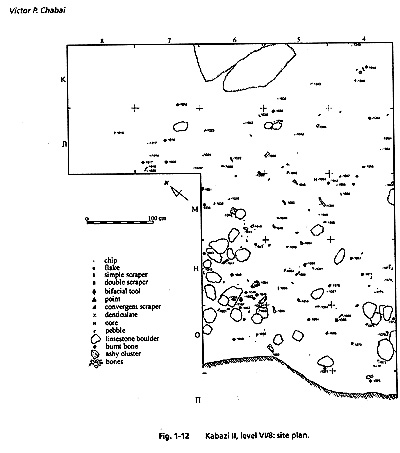 Fig.
1-11 Kabazi II, level VIA: site plan. Fig.
1-11 Kabazi II, level VIA: site plan.
CHRONOLOGY
The
chronological investigations of Kabazi II are based on the
radiometric methods of datation and on extensive environmental
studies (Hedges et al. 1996, Pettitt 1998, Rink et al. 1998,
in press, McKinney 1998, Gerasimenko 1999, Chapter 2, this
volume, Markova 1999, Chapter 3, this volume, Mikhailesku
1999, Chapter 4, this volume, Chabai et al. 1998, 1999).
One
bone sample taken from deposits of Stratum 4 (level 1/3)
was dated by AMS: OxA-4135, 34940+1020. Taking into account
the secondary context of this sample, this date is of little
significance.
Unfortunately,
no dates exist for Stratum 5, although two samples of tooth
from Stratum 6 (level II/1A) were dated by U-series and
ESR methods (Table 1-1). According to the results from the
pol¬len analysis conducted by Gerasimenko, both Strata 5
and 6 accumulated under the climatic conditions of Vytachiv
vt3b (Denekamp Interstadial). The U-series date mentioned
above can, however, neither prove nor disprove this conclusion,
owing to the extremely
P.18 |
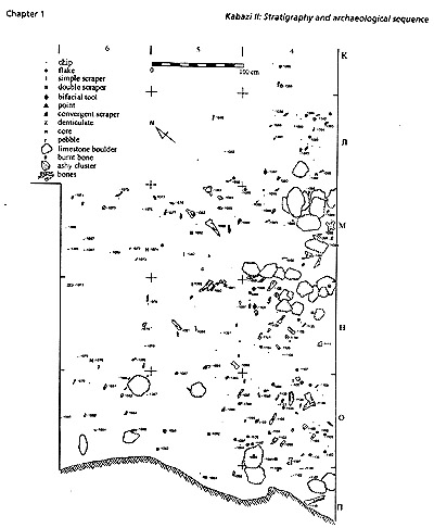
Fig.
1-13 Kabazi II, level VI/9A: site plan.
large
standard deviation. The ESR date is the average result
of samples taken from three teeth. These samples were
treated twice. The first mean ESR date is 32±6, the
second is 30±2 (Rink et al. 1998, in press). If the
first EBR date is very close to the U-series date and
does not give sufficient information regarding the age
of the level II/l A sample, the second more or less
corresponds to the commonly adopted age of the Denekamp
Interstadial (Table 1-1). Additionally, the lower deposited
occupations (levels II/l - II/5) were dated by AMS to
30 - 35 ka BP.
One
might considerthis an additional, but indirect argument
dating levels II/1A - A3A to the Denekamp period (Table
1-1). The sediments belonging to Stratum 7 this an
additional, but indirect argument dating levels II/1A
- A3A to the Denekamp period (Table 1-1).
The
sediments belonging to Stratum 7 accumulated under the
climatic conditions prevailing in Vytachiv vt, (Huneborg
Stadia]), Vytachiv vtlc (Huneborg Interstadial) and
Vytachiv vtib2 (Hengelo Interstadial). Furthermore,
a gap was observed in the pollen spectrum in the middle
part of Stratum 7 (Table 1-1). AMS dates were made on
bone samples from levels II/l, II/2 (Vytachiv vt, -
Huneborg Stadi-al) and 11/4, II/5 (pollen gap). According
to P. Pettitt'saccu¬mulated under the climatic conditions
prevailing in Vytachiv vt, (Huneborg Stadia]), Vytachiv
vtlc (Huneborg Interstadial) and Vytachiv vtib2 (Hengelo
Interstadial). Furthermore, a gap was observed in the
pollen spectrum in the middle part of Stratum 7 (Table
1-1). AMS dates were made on bone samples from levels
II/l, II/2 (Vytachiv vt, - Huneborg Stadi-al) and 11/4,
II/5 (pollen gap). According to P. Pettitt's
P.19 |
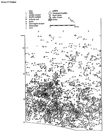
Fig.
1-14 , Kabazi II, level VI/11-14: site plan.
analysis
of the AMS chronology from the upper part of Stratum
7, all dates are statistically identical, and the levels
II/l to II/5 can be dated to between 31 and 36 ka BP
(Table 1-1).
If
we disregard the date from level II/2, this time period
then shrinks to between 31 and 34 ka BP (Pettitt 1998:
334). J. Rink's analysis of all the available dates
from Kabazi II has led him to the conclusion that levels
II/l down to II/5 fall within the 30 - 35 ka BP range
(Rink et al. 1998: 336, Rink et al. in press).
There
were two attempts to date samples of tooth taken from
the lower part of Stratum 7 using the ESR method. The
levels II/7AB-II/8 accumulated under the climatic conditions
of Vytachiv vtlb2 (Hengelo
P.20 |
Interstadial)
(Table 1-1). A first attempt to date two samples from
level II/7AB produced two ESR, LU ages: 34±2 and 29+3
ka BP (Rink et al. 1998: 333-334). Meanwhile, the same
teeth have been analysed again, which has resulted in
new ESR, LU results: 38±4 and 36+3 ka BP (Rink et al.
in press). The single tooth from level II/8 has been analysed
twice. The first ESR, LU result is 39±3, while the second
is 44+5 ka BP (Rink et al. 1998: 333-334, Rink et al.
in press).
There are also two U-series
dates from levels II/l and II/7 (Table 1-1). Unfortunately,
both have considerable standard deviations making them
quite useless in furthering our understanding of the chronological
position of these levels. Nevertheless, C. McKinney who
has analysed the U-series chronology "of Unit II
as a single unit", decided that its U-series age
is 39,8+5 ka BP (McKinney 1998: 348).
In sum, the conclusions
made by Pettitt, Rink and McKinney concerning the AMS,
U-series and ESR ages of the samples from Strata 6 and
7 are not in contradiction with the results obtained from
the pollen studies (Table 1-1).
There are no radiometric
dates for the levels from Strata 9,10, and the uppermost
part of Stratum 11 which accumulated under the climatic
conditions of Vytachiv vtlb, (Hengelo Interstadial), Vytachiv
vtib2-bi (Stadial), Vytachiv vtlbl (Moershoofd Interstadial),
Uday Stadial and Pryluky p^ (Ognon Interstadial) (Table
1-1).
Samples of tooth taken
from level III/2, in the upper part of Stratum 11 (Pryluky
pl]b2 - Odderade Interstadial) have been dated by U-series
and ESR methods. Three teeth from level III/2 have produced
an average U-series age of 60±3, but using the average
error of the samples, it "is equivalent to an age
of 54,000±3,000 years BP" (McKinney 1998: 348). Another
three samples of tooth taken from the same level have
produced U-series ages from 41,1±2 to 117±12/13 (McKinney
1998: 347).
More successful were the
attempts to date three further samples of tooth from level
III/2 by ESR method. The average result of these is as
follows: ESR, EU, 51±3 and ESR, LU 61±1 ka BP (Rink et
al. 1998: 334-335). These same samples have since been
reanalysed, and Rink is of the opinion that the best age
for level III/2 is 74 - 85 ka BP (Rink et al. in press).
This age is not contradict the commonly adopted ages of
Pryluky pllb2 - Odderade Interstadial and the assumed
chrono¬logical boundary between isotopic Stages 4 and
5 (Table 1-1).
At least three attempts
have been made to date a single tooth from level III/3
using the ESR method. This level was found in the deposits
of Stratum 11, lower (Pryluky pllb2_b] (pl2) - Rederstall
Stadial - isotopic sub-stage 5b). A first attempt resulted
in a date of 82±6,4 ka BP (McKinney, Rink 1996). A few
years later the same sample have produced two further
dates: ESR, EU, 53+4 and ESR, LU 69±5 (Rink et al. 1998:
333, 335). A final variant is: ESR, EU, 61±6 and ESR,
LU, 82±10 (Rink et al. in press). The oldest dates, such
as 82±6,4 and 82±10, are close to the commonly adopted
age for isotopic sub-stage 5b (Table 1-1).
The lower part of the Kabazi
II sequence, which is represented by the deposits from
Strata 1 I/lower, 13, 13A, 14A and 14B, and were accumulated
under the climatic conditions of isotopic sub-stages 5c
and 5d (Table 1-1), have still not been dated by radiometric
methods. Therefore, the chronological investigations of
the Kabazi II sequence are still quite far from reaching
its conclusion. The present day version might be viewed
as the intermediate version of the Kabazi II chronology.
At the same time, and taking into account the completeness
of the pollen record (Gerasimenko, Chapter 2, this volume)
and its good correlation with lithopedological, micro-fauna
(Markova, Chapter 3, this volume) and ma-laco-fauna (Mikhailesku,
Chapter 4, this volume) data, as well as the absence of
dramatic contradiction between environmental and radiometric
data, it is possible to state the main temporal framework
of the Kabazi II archaeological sequence:
-
The earliest occupations of Units VI and V (Strata 14B
and 14A) accumulated in Eemian soil un der Interglacial
climatic conditions of isotopic sub-stage 5d.
-
The next soil formation process, as seen in the formation
of the upper part of Stratum 11, cor responds to the
isotopic sub-stage 5a and has been dated using the ESR
method to between 74 and 85 ka BP (level III/2).
-
A further period of soil formation in the low er part
of Stratum 7 (levels II/7AB-1I/8) corre sponds to Vytachiv
vtlb2 - Hengelo Interstadial, and has been dated by
ESR to 44±5 ka BP.
-
The last Pleistocene soil accumulated in Stratum 5,
under the climatic conditions of Vytachiv vt3b - Denekamp
Interstadial. This period comprises the archaeological
levels A3A - A4.
P.21 |
©Victor P. Chabai
|